When you’re dealing with property ownership, land boundaries, or subdivision projects, one of the most critical yet often overlooked steps is getting a cadastral survey done. Many property owners don’t realize that a Cadastral Survey isn’t just a technical formality—it’s a legal requirement in certain cases. Without it, your property rights, boundaries, or future transactions could be challenged, leading to unnecessary disputes or costly delays.
If you’re wondering when a cadastral survey in Edmonton becomes mandatory and who’s supposed to pay for it, here’s a detailed guide to help you understand the process.
When a Cadastral Survey Is Required
A cadastral survey defines, measures, and officially records property boundaries for legal purposes. It becomes mandatory in a number of situations involving land ownership and development.
- When transferring property ownership. If you’re buying or selling land, especially a parcel that hasn’t been clearly defined before, a cadastral survey ensures the boundaries are precise and legally recognized. Land titles can’t be accurately registered without a verified survey plan, making this step essential before finalizing a sale.
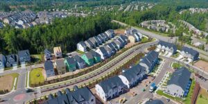
- During land subdivision or consolidation. Developers or landowners who plan to divide a property into smaller lots—or combine multiple lots into one—are legally required to have a cadastral survey. The survey ensures that each resulting lot has clear, legally recorded boundaries before it’s issued a new title. This helps prevent future disputes among buyers or between neighboring properties.
- In boundary disputes. When two landowners disagree about the location of a property line, a cadastral survey provides the official evidence needed to settle the issue. It relies on precise measurements, previous land records, and government benchmarks to determine where one property legally ends and the other begins.
- Before major construction or development. Municipalities often require a cadastral survey before granting building permits, especially for large-scale or high-value projects. It helps ensure the planned construction complies with zoning regulations, setbacks, and easements. Skipping this step could result in costly corrections or even legal action later on.
Who Pays for the Cadastral Survey?
The question of payment depends on who benefits from or initiates the survey.
- Property buyers and sellers. In a typical real estate transaction, the seller is often responsible for providing an up-to-date cadastral survey to verify the property’s boundaries. However, some buyers choose to commission a new survey themselves to ensure accuracy before purchase—especially if the property’s boundaries are unclear or have changed due to fencing, landscaping, or nearby development.
- Developers and subdividers. When a developer initiates a subdivision or consolidation, they bear the full cost of the cadastral survey. This includes all mapping, documentation, and registration fees. While it may seem like an additional expense, the survey helps ensure legal compliance and protects against future land ownership conflicts.
- Neighbors in dispute. For boundary disagreements, the cost is usually shared by the parties involved, though this can vary depending on local regulations or agreements. Some municipalities may even require both parties to hire a licensed surveyor to ensure fairness in the process.
So before signing a property deal or beginning construction, make sure a qualified professional has conducted a cadastral survey in Edmonton. It’s one of the smartest steps any landowner can take to safeguard their investment and avoid boundary-related headaches down the road.
For More Information About Land Survey Company Regina and Land Surveying Saskatchewan Please Visit: Core Geomatics.