When it comes to buying, selling, or developing land, knowing exactly where your property boundaries lie is essential. That’s where cadastral surveys in Edmonton come in. These detailed surveys provide accurate information about land ownership, property lines, and legal boundaries, helping property owners avoid disputes and costly mistakes. Whether you’re a homeowner, developer, or investor, understanding the role of cadastral surveys is crucial for making informed decisions about your property.
What Are Cadastral Surveys?
A cadastral survey is a type of land survey that establishes, marks, and records the precise boundaries of a property. These surveys are registered with the appropriate land titles office and form the legal foundation for defining property ownership.
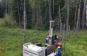
In cadastral surveys in Edmonton, licensed land surveyors use advanced equipment and mapping techniques to measure the land accurately. The final result is a certified survey plan that becomes part of the public record, ensuring clarity on where your property begins and ends.
Why Cadastral Surveys Matter
Property disputes often arise when boundaries are unclear. Without proper surveys, homeowners and developers risk building on land they don’t actually own—or leaving portions of their property unused due to uncertainty. A cadastral survey eliminates this guesswork by providing an exact layout of your land.
Here are some key reasons cadastral surveys in Edmonton are essential:
- Preventing boundary disputes – With clearly defined property lines, neighbours can avoid disagreements over fences, driveways, and shared spaces.
- Ensuring compliance with regulations – Municipalities often require cadastral surveys for development permits, subdivisions, or rezoning applications.
- Facilitating smooth property transactions – Accurate surveys make it easier for buyers, sellers, and lenders to proceed with confidence, knowing there are no hidden issues with the land.
- Protecting your investment – A well-documented survey ensures your property rights are legally protected, reducing the risk of costly legal battles.
When Do You Need a Cadastral Survey?
There are several situations where ordering cadastral surveys is highly recommended—or even mandatory:
- Purchasing a property – Before finalizing a sale, a cadastral survey confirms that the boundaries match what’s stated in the title documents.
- Developing or subdividing land – If you’re planning to build, renovate, or split your land into multiple parcels, accurate surveys are required to get the proper approvals.
- Resolving encroachment issues – When structures like fences, sheds, or driveways cross property lines, a cadastral survey helps determine the rightful boundaries.
- Updating legal records – Over time, property boundaries may shift due to natural changes or outdated mapping. A current survey ensures your records are accurate.
The Process Behind Cadastral Surveys
Conducting cadastral surveys involves several steps:
- Research & data collection – Surveyors gather historical records, previous surveys, and legal documents related to the property.
- Fieldwork & measurements – Using GPS, total stations, and other high-precision tools, they measure the land to establish exact boundaries.
- Analysis & mapping – The collected data is analyzed and converted into a detailed survey plan.
- Registration & records – Once completed, the survey is filed with the appropriate land registry to ensure it becomes part of the official property records.
For property owners, developers, and investors, cadastral surveys are more than just technical measurements—they’re a safeguard for your property rights. By clearly defining your land boundaries, they help you avoid disputes, comply with regulations, and make informed decisions about your investments.
If you’re planning to buy, sell, develop, or subdivide land, consider arranging cadastral surveys in Edmonton before moving forward. It’s a small step that can save you from big problems later.
For more Information about Real Property Reports Services Saskatoon and Land Survey Services Regina Please Visit: CORE Geomatics.