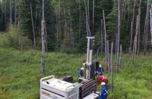
Before any construction or land development project begins, one of the most important steps is understanding the lay of the land. Elevation data, which provides a detailed picture of a site’s highs and lows, is not just technical information—it’s critical to ensuring safety during planning, construction, and even long after a project is completed. This is where topographic surveys in Edmonton play a vital role.
Preventing Drainage and Flooding Hazards
Elevation data identifies the natural flow of water across a property. Without this information, developers may overlook areas prone to pooling, erosion, or flooding. Improper drainage can lead to unsafe working conditions during construction and long-term hazards for future occupants.
For example, knowing the slope of the land allows planners to design proper drainage systems that guide water away from foundations, roads, and other critical structures. In areas with heavy rainfall or snowmelt, this information becomes even more essential. With the help of topographic surveys in Edmonton, potential water hazards are spotted early, reducing risks of flooding and soil instability that could otherwise compromise site safety.
Reducing Risks During Excavation and Grading
Construction often involves reshaping land to create a stable foundation. This requires excavation, grading, and in some cases, cutting into slopes. Working blindly without accurate elevation data could put workers at risk of landslides, collapses, or improper grading that destabilizes structures later on.
Topographic surveys provide precise data that helps engineers determine safe excavation depths, proper slope angles, and areas requiring reinforcement. By preventing unexpected soil movement or instability, they reduce the likelihood of accidents during construction. Elevation mapping essentially acts as a guide to ensure every dig and cut is done with safety in mind.
Enhancing Structural Stability
Buildings, roads, and utility lines all depend on stable ground. Uneven or unpredictable terrain poses risks that can compromise both construction crews and the future users of a site. A topographic survey highlights variations in elevation that might affect how a structure settles or shifts over time.
Armed with this knowledge, engineers can design foundations that suit the terrain, reducing risks of cracks, uneven settling, or even structural failure. For projects like bridges, retaining walls, and multi-level developments, understanding elevation differences is especially critical. Topographic surveys in Edmonton help ensure that structures are designed not just for functionality, but also for long-term safety.
Supporting Safer Construction Planning
Safety on a construction site is not only about equipment and protective gear; it also involves smart planning. Knowing the location of slopes, embankments, and elevation changes allows site managers to organize work areas more efficiently.
Heavy machinery, for example, is safer to operate on level ground. With detailed elevation data, site planners can decide where to safely position cranes, trucks, and storage areas. Even simple tasks like setting up walkways or temporary scaffolding benefit from this information, reducing the chance of accidents caused by uneven terrain.
Elevation data is far more than a set of numbers on a map—it is a safeguard against hidden risks in construction and land development. Through topographic surveys in Edmonton, developers, engineers, and planners gain the clarity they need to design safe, sustainable, and long-lasting projects. From preventing flooding to supporting structural integrity, topographic surveys ensure that every project begins with a solid foundation of safety.
For More Information About Land Survey Services Saskatoon and Residential Land Survey Regina Please Visit: CORE Geomatics.