Surveying has always required precision, patience, and time spent outdoors in varying conditions. Across Edmonton, however, the profession is evolving rapidly. Modern tools and digital workflows are transforming how projects are completed, allowing teams to gather accurate data faster while reducing hours spent on-site. An experienced Edmonton survey company now relies heavily on innovative technology to streamline operations, improve safety, and deliver results more efficiently than ever before.
Below is a closer look at how today’s surveyors are using technology to reduce field time without compromising accuracy.
The Rise of GNSS and Robotic Total Stations
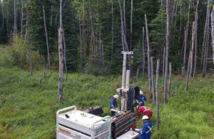
Global Navigation Satellite Systems (GNSS) have become a foundational tool for survey crews. Unlike traditional methods that required multiple setups and extensive manual measurements, GNSS receivers provide precise positioning data in real time. This allows surveyors to collect topographic information, boundary points, and control data in a fraction of the time previously required.
Robotic total stations have also transformed fieldwork. Operated by a single surveyor using remote controls and automated tracking, these instruments eliminate the need for larger crews on many projects. An Edmonton survey company equipped with robotic systems can complete layout and data collection tasks more efficiently, minimizing both labour costs and time on site.
Drone Technology for Faster Data Collection
Unmanned aerial vehicles (UAVs), commonly known as drones, are now widely used across Edmonton for surveying large or complex sites. Drones capture high-resolution aerial imagery and generate detailed topographic maps using photogrammetry software. What once required days of ground-based measurements can now be completed in hours.
Drone surveys are especially useful for construction sites, subdivisions, and rural properties. They reduce the need for crews to traverse difficult terrain and help improve safety by limiting exposure to hazards.
3D Laser Scanning and LiDAR
Three-dimensional laser scanning and LiDAR technology are further reducing field time for surveyors. These systems collect millions of data points in minutes, producing highly detailed digital models of structures, landscapes, and infrastructure.
For construction and engineering projects, this level of detail significantly reduces the need for repeat site visits. Instead of returning to capture missed measurements, surveyors can extract precise dimensions directly from the digital model. An Edmonton survey company utilizing 3D scanning can provide clients with comprehensive datasets that support design, renovation, and expansion projects with exceptional accuracy.
Real-Time Data Processing and Cloud Integration
Field efficiency is not only about collecting data quickly; it also depends on how that data is processed and shared. Modern survey equipment integrates directly with cloud-based platforms, enabling real-time uploads from the field. Office teams can begin processing information immediately, reducing downtime between fieldwork and final deliverables.
This seamless transfer of data allows surveyors to identify potential discrepancies early, preventing costly revisits. Digital collaboration tools also improve coordination between field crews and office staff, ensuring projects move forward without unnecessary delays.
Improved Safety and Reduced Environmental Impact
Technology-driven surveying methods contribute to safer and more sustainable practices. Smaller crews, shorter site visits, and remote data collection all reduce exposure to traffic, heavy equipment, and harsh weather conditions. In Edmonton’s diverse climate, minimizing time spent outdoors can significantly improve overall safety. Additionally, fewer trips to a project site mean reduced fuel consumption and lower environmental impact.
For property owners, developers, and contractors, working with an Edmonton survey company that embraces advanced technology offers clear advantages. Faster turnaround times, improved accuracy, and enhanced safety all contribute to more successful projects.
For More Information About Land Surveying Regina and Real Property Reports Saskatoon Please Visit: Connexa Group.