Planning a development project involves more than just blueprints and ideas—it requires precise information about the land itself. Municipalities rely on accurate data to approve or reject construction proposals, and skipping critical steps can lead to costly delays. One of the most essential tools for any property project is a topographic survey. These surveys provide detailed insights into the physical features of a property, ensuring that your plans align with reality.
What Topographic Surveys Include
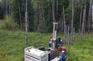
Topographic surveys are much more than lines on a map. They record the contours, elevations, and slopes of a parcel of land, along with natural and man-made features such as trees, fences, drainage systems, and roads. This information is crucial for architects, engineers, and planners to design structures that work harmoniously with the landscape rather than against it. Without a proper survey, municipalities may not have enough data to evaluate whether a project is safe, feasible, or compliant with local regulations.
Flood Risks and Drainage Challenges
One common reason proposals are rejected is because municipal planners cannot accurately assess flood risks or drainage issues. A topographic survey identifies how water moves across a property, highlighting low-lying areas or drainage challenges. Ignoring these factors can result in plans that put buildings at risk or disrupt the surrounding environment. By providing detailed elevation data, topographic surveys help prevent these issues before construction even begins, giving municipalities confidence in the project’s viability.
Importance of Grading and Slope Management
Certain developments require land to be leveled or graded to specific standards. Without precise measurements, construction crews may miscalculate the amount of fill needed, or worse, fail to meet municipal safety requirements. Topographic surveys ensure that elevation changes are clearly documented, allowing for accurate grading plans that comply with building codes and safety regulations.
Property Boundaries and Compliance
Topographic surveys are also critical for determining property boundaries and easements, even when a property appears straightforward. They show the exact location of features relative to the land’s legal description, reducing the risk of encroachment or disputes that could stall approval. Municipal authorities depend on this information to verify that your plans respect zoning setbacks, environmental buffers, and other land-use requirements.
Saving Time and Money with Early Surveys
Investing in a topographic survey early in the planning process saves both time and money. Projects without accurate surveys often face multiple rounds of revisions, delaying approvals and increasing costs. In contrast, a well-documented survey allows designers to optimize layouts, identify potential challenges, and present a thorough, professional plan to municipal officials. It’s a proactive step that demonstrates commitment to compliance and responsible development.
Partnering with Topographic Survey Professionals
For those considering property improvements, renovations, or new construction, working with experienced professionals who provide topographic surveys in Edmonton is essential. They can deliver precise, reliable data that meets municipal standards and reduces the risk of plan rejection. A detailed survey gives decision-makers the confidence that your project is practical, safe, and fully compliant.
Skipping a topographic survey is a risk no developer should take. Municipalities require concrete, verifiable data to ensure that projects will not cause flooding, erosion, or other land-related issues. By securing comprehensive topographic surveys in Edmonton early on, property owners can avoid unexpected setbacks, costly revisions, and frustration, paving the way for smoother approvals and successful development outcomes.
For More Information About Land Survey Company Regina and Land Survey Services Saskatchewan Please Visit: Core Geomatics.